Please note special directions regarding Lectures 9 + 10 which will be collected over the course of two blog posts.
Please post your comments here for Lecture 9 first - see below.(Early comments give all students more traction for course participation - and a chance to earn more points for participation! Comments this Lecture are due on Friday, for Part II by Monday, see each post for specific details)
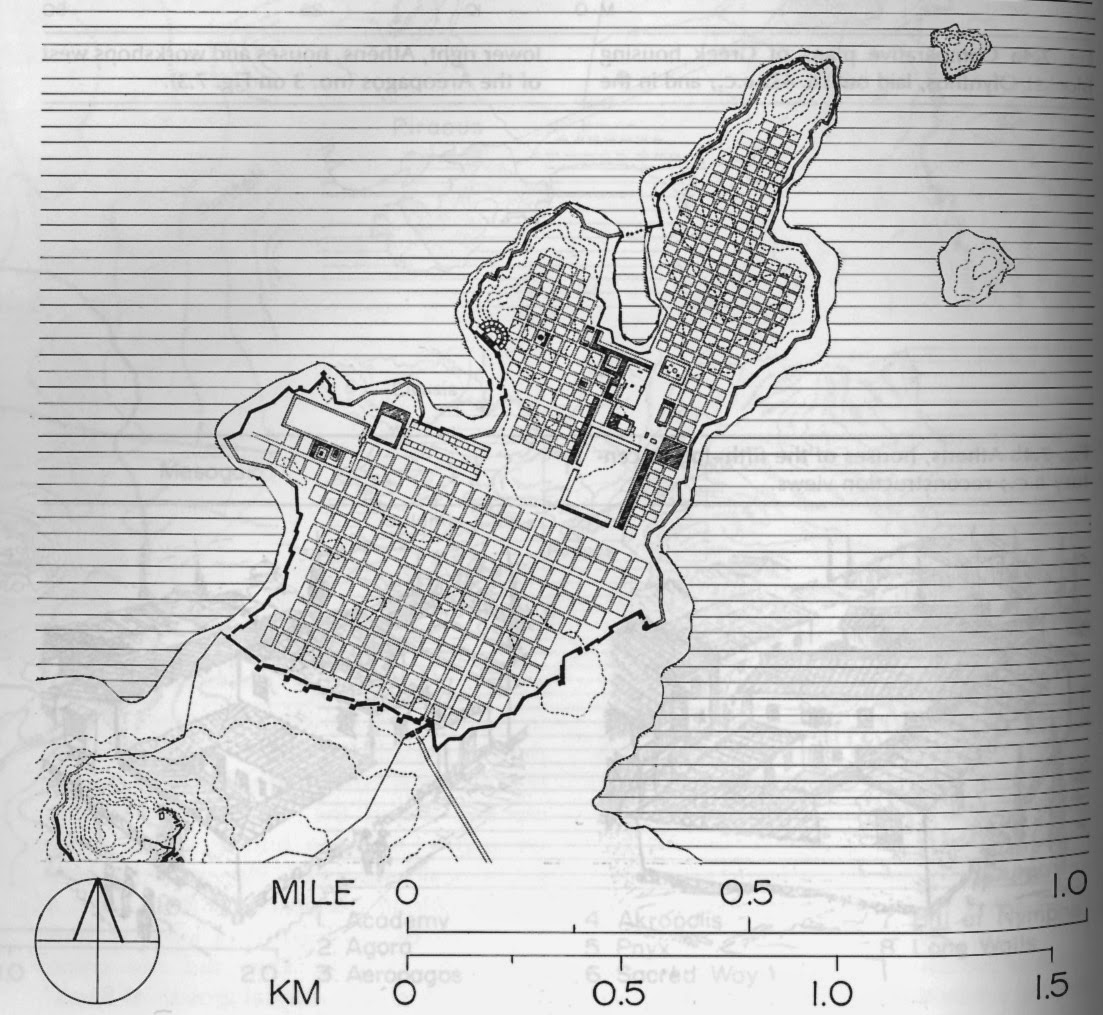
Study of Delos: Part 1
This series of double-loaded lectures detail the Greek city of Delos. (Here is a link to it's location in the Aegean Sea viewable on Google Maps) The first lecture describes the history and evolution of the city, in the second lecture we will start to examine in finer detail the effects of the planning and evolution of the city.
As you read both the lectures consider the question you will have to answer at the end of Lecture 10 - "How do American cities resemble Hippodamus's?"
This question may at first seem as though it can be answered in a few short comparisons - but I challenge you to look deeper in the planning and the evolution of Delos in your comparisons as well.
There are two very important premises to keep present in your mind during the unfolding of this course:
The city is a constantly changing, adapting, evolving expression of the people who live within it, their lives, their plans, it is functional, cultural, and built on the traces of the history of the spaces and places that together make what we know as "the city".
Philadelphia itself is an excellent living classroom/laboratory to explore and find examples of what we are reading about and talking about in the class.
The resources of the internet now mean that you can visit Delos virtually flying overhead via Google Earth or Google Maps; the latter also includes geo-tagged photos of the ruins - utilize the resources to get a better feel for the layout and scale of this ancient city.
 |
| Illustration of Miletus, a city of ancient Greek origins located in modern day Turkey. Illustration thanks to online archive of Prof. of Geography, Dr. Richard Fusch, at Ohio Wesleyan University |
Questions for Lecture 9:
Give an example of an American City (better yet a specific area of that city) that follows Hippadamus's rationale; Where is this rationale most notable? What are the benefits of that rationale? How has that planning affected your perception of that space/place/neighborhood? Where is a space/place which departs from that rationale - why do you think that happened?
Comments for Lecture 9 are due by Friday March 4th
10 comments:
Phil S.
Lecture 9 response:
Hippodamus believed that the form of cities should be governed by certain scientific principles. Earlier Greek cities, such as Delos, where delineated between the sacred and the profane, and the juxtaposition of buildings was based on honoring Greek temples instead of making practical use of space. Hippodamus was the first to suggest the “grid city” style of city building, thus becoming the first to “plan” the construction a city. While the Greek leaders of his era did not believe this to be a practical way to create a city, it’s obvious that it has become a staple in modern city planning.
A perfect example of the adoption of Hippodamus’s rationale is the original city of Philadelphia, Center City. Just as Hippodamus believed that the best way to facilitate commerce in a city and to maximize land use efficiency, William Penn and Thomas Holme designed Philadelphia to facilitate commerce, prevent mass house-fires (by separating each city block with wide streets), and maintaining a sense of Quaker uniformity and conservatism with mostly identical, equidistant residential blocks.
In modern times, in which we don’t have to worry very much about the threat of mass house-fires, the grid network of center city still has its benefits. One important benefit is that the grid system, with its equal parallels and meridians, serves to disperse road traffic equally. Broad and Market streets are meant to host the most traffic, while the rest of the streets are meant to have lighter traffic. Even when there is a road blockage due to an accident or construction, the grid system ensures that a viable street is no more than 1 or 2 blocks away. In many ways, the grid system makes the city seem much more accessible, both for pedestrians and vehicles.
There are, of course, interruptions to the otherwise consistent grid system of Center City’s streets. Benjamin Franklin Parkway, which stretches from JFK Plaza to The Art Museum, is a major interruption to the grid system. Now, especially since it has been under construction it forces drivers to go well out of their way to access points in Center City that they otherwise would have direct access to under the grid system. Of course, it does offer a faster route to the Museum and Fairmount, but has turned a major portion of Center City into a complicated auto-centric road network.
Hippadamus’s Rationale in Philadelphia City
The great city of Philadelphia is a place whose constant growth and expansion can be attributed to the Hippadamus’s rationale. For instance, the space where the Cathedral Basilica of Saints Peter and Paul church is positioned to utilize the rationale in a straightforward manner. Just like the island of Delos in ancient Greece, the Cathedral Basilica of Saints Peter and Paul Church was constructed in a precinct created by the surrounding building and street lanes such as the Logan Square and the Benjamin Franklin Parkway. This architectural design delineated the sacred space within which the Cathedral Basilica of Saints Peter and Paul church is located from the profane space where daily activities take place.
Benefits of the Rationale in Philadelphia
The Hippadamus’s rationale has enabled the demarcation of the sacred space from the profane space in the city of Philadelphia. Moreover, this distinct separation of the two areas has prevented religious activities from being disrupted by profane practices, and the converse is true. The rationale has also enhanced the growth and expansion of the city of Philadelphia through the perfect use of space. In fact, the rationale has prevented the wastage of space during construction of buildings.
Perception of Space
The rationale has enabled the planning of Philadelphia city in an architectural manner such that even a small space or precinct can be used to construct a building that can benefit the people of Philadelphia. The utilization of space, therefore, can be well organized to accommodate everything an individual needs, regardless of the size of the space. Nonetheless, the Old Pine Street Presbyterian Church in Philadelphia departs from this rationale. The place integrates both the sacred space and the profane voids into one thing. There is no delineation between the sacred space and the profane void. The probable reason for this integration is the fact that the Old Pine Street Presbyterian Church and the Old Pine Community Center where activities other than religious practices are conducted are constructed within the same space. There is no space or precinct separating the two places.
Lecture 9:
New York City’s landscape is a structured grid that has transformed the island on which Manhattan sits. At first using Hippadamus’ rationale it looks strictly structured but looking closely its as though the neighborhoods within Manhattan have their own defined grid that delineate from the rest of the city’s structure. For example the area that is Greenwich Village curves away forming a separate grid like system. While systematic it is a condensed grid within a larger one that continues to the Hudson River. This pattern continues in the southern tip of Manhattan where another condensed grid takes shape to the edge of the water. A closer look at the landscape of the island shows that the grid is defined by the islands shape and the neighborhoods have transformed to fit them over time. While organized it is unique in form due to the surrounding water culture that has formed within its boundaries. Starting at Greenwich Village and south of the East Village the island of Manhattan begins to shrink and thus so does the city grid and it breaks apart separating some neighborhoods from others defining the city culture within it.
Woojae H.
Hippodamus was an architect who contributed a lot to city plannings. His rationale about building a city was to build a city in a rectangular grid. He thought that having a city built on rectangular grid made it more efficient for protecting the city from invaders. Also, based on his rationale, the city should be divided into parts as different parts of cities have different purposes and public spaces and buildings should be gathered in the center of the city. These principles can be related to the concept of separation between the sacred and the profane that we have learned in previous lectures.
The city that I choose to write relating to this lecture is Philadelphia. Philadelphia is a good example to relate this lecture to. There is center city Philadelphia where all public spaces and buildings are gathered altogether in the center of the city. There is Philadelphia Convention Center which has a lot of public purposes. Philadelphia Convention Center can be an example of a public space being located in the center of the city which was an architectural concept that was introduced by Hippodamus. Also, many companies are there in Philadelphia as well that people go to work to the city while they usually reside away from the center city. I suppose that working spaces being gathered in a massive group in the center city Philadelphia can also be related to that of Hippodamus.
The benefits of building a city on Hippodamus’s rationale are that the city can be more organized that spaces can be located easier, and it is more efficient. By building a city on a rectangular grid, people can easily find where they want to go because, I assume, addresses can be given to places based on which roads the buildings were located nearby. Also, by having public spaces, the sacred, in the center and other spaces that are for living necessities, the profane, around the center, based on Hippodamus’s rationale, the city can run more efficiently. I suppose that due to concentrated population movement from outer space to the center, the roads can be built in a larger scale to meet the need. Also, places for public can be all gathered in the center of the city making those buildings easier to be accessed because people need to look no further but just need to go to the center of the city to find those spaces needed for public.
My perception of the center city Philadelphia, and cities in general, has changed a lot after learning from this lecture about Hippodamus’s rationale. It made me think about the city as a whole how it is constructed with public spaces in the center and living spaces around it and why it was built this way at first. I was not aware of the fact that city was built this way for specific purpose by architects.
Any spaces that departs from Hippodamus’s rationale are, in my opinion, those residential areas in the center city Philadelphia. According to Hippodamus’s rationale, public spaces are to be gathered in the center of the city and living spaces are to be outside of the center. However, there are living spaces in the center of the city as well. I suppose that living spaces were created in the center of the city to meet some people’s needs. Some people who wanted quicker access to those public spaces would prefer to live in the center city. Also, people may choose to live in the center of the city because they want to enjoy the privilege being near other types of spaces that were created in the center of the city due to increased population concentration.
Hippadamus was a man of great knowledge. He spent much of his time thinking about the process of planning on all scales. He wrote about government and city planning. He was a man of many attributes which is partially why he is considered the “father” of urban planning. He created the gridded system that has been replicated and recreated in many modern cities, especially in the United States. Much like the founder of urban planning William Penn too was a man of great wisdom. He not only developed and founded Pennsylvania but also created one of the greatest cities in Pennsylvania, Philadelphia. When this city was first founded between South Street, North Street, the Schuylkill and the Delaware River it too was set up off of Hippadamus’s grid system. In doing so it allowed Philly to map out space for one hundred years. This system works really well which is why so many tend to use it. In the order of Old City places were set up to house government conferences, recreational activities, day to day business, and a very important port that connects us with New Jersey. In the early plan of Philadelphia you can see the city laid out with great order everything was situated in some way shape or form. The parts of the puzzle came together to create an interesting city. As the city grew however the rationale was lost and streets such as Ridge and Germantown began to splice the grid. In doing so it caused the grid system to begin to adjust to these rows which can be seen as you travel through parts of the city such as Fishtown. Growth is one of the hardest things to plan for because nowadays the possibilities are endless as technological advances come out. Which is why the city plan grew as it did. The importance of the train systems created a connection for all sides to get too but also shaped the form that Philadelphia took.
Steffanie M.
Lecture 9
The original plan for Washington Dc is a great example of Hippadamus’s ideal of a rational city plan. The city is first separated into four quadrants, NE, NW, SW, and SE. These quadrants are generated by drawing a lines radiating from the Capital buildings running north, south east and west. Then within each of the quadrants are the streets named and labeled so one may know not only which quadrant they are currently in, but if they are heading towards or away from the Capital building by the virtue of the naming convention used.
If we also look at the city of Miletus we see that the city just wasn’t planned on a grid, but important structures were centralized more or less within the city. If you draw a line from the NW to SE, through the narrowed section of the peninsula in which Miletus is built we see the city broken into two halves, with the majority of the major civic and public buildings having been built along this line. The most important of these structures built just off this line in the northern half of the city, a rational decision as the city’s harbor was located within the northern half of the city, further more the only route by land to attack the city was from the south. So as we can see Hippadamus’s concept of the rational city plan, wasn’t just to make a city a grid and then it is rational, but the location of certain buildings and sites must be thought out as well.
Looking back to Washington DC and its quadrants, they all originate at the Capital building. Washington DC was a city built expressly for the purpose of housing the government, the most important aspect of the government in the eyes of the founding fathers was the house of the legislative branch. So the idea of having a city which was created solely to house the Nations government, with the building which is looked upon as the seat of the government at its heart, well it’s certainly symbolic but completely rational as well. No matter which direction you travel from the capital, it is surrounded, protected, and supported by the city.
Hippadamus contributed to American cities by introducing a more logical sense of city planning. The previous form of planning was the hodological approach, where the city appears chaotic but is organized around the unique meaning of each building. There is no physical order, but the buildings are organized by purpose and remembering that, each site can be easily located. This system works well for the cities of 5,000 people found in Ancient Greece, but in a much larger scale that includes tourists, there needed to be a more simple solution.
Hippadamus introduced the grid system, which was utilized when Philadelphia was first organized. The most notable benefit of this grid system is that the streets can be numbered in a logical order, so that to get from 32nd Street to 30th Street, one would only need to turn left and travel two city blocks. This has made traveling and understanding a city much easier and logical.
Much like the city of Delos, Philadelphia has struggled with keeping the sacred buildings from the profane. City Hall is a perfect example of this struggle. The city was organized so that City Hall would be in the center, and the statue of Ben Franklin on top was meant to symbolize the highest point in Philadelphia. At the time, it was decreed that no building should be built higher, to retain the value of this government building as the most important in the city. With a worldwide demand for expansion, Philadelphia had no choice but to built buildings taller, and the effect of this decision persists today. City Hall has not been moved or altered to this day, though it is now surrounded by skyscrapers. In order to keep it visible and keep it in the center of the city, the grid system had to be sacrificed. The circle around the building disrupts traffic and makes traveling around that area very difficult, but the struggle is a great example of the value of the sacred. The placement of City Hall is clearly a burden, but because of its sacred significance, Philadelphia has worked hard to keep it where it is.
The example of an American City I want to talk about is Boston, which is the capital and largest city of the Commonwealth of Massachusetts. Boston is quite similar to Delos. At the beginning, Boston is a small island as well as Delos surrounded by the Massachusetts Bay and Charles River and connected to the mainland by a narrow isthmus. Everything started around the harbor area. Boston used to be one of the most important harbor city in America which connect to Europe closely. Therefore, there are some most important main streets cross over the city, surrounding the three mountains that Boston used to have. Also, Boston became quite busy with increasing number of population due to factories business and international trading. Nowadays, more than two-thirds of inner Boston's modern land area, which did not exist when the city was founded, was created via the gradual filling in of the surrounding tidal areas over the centuries by leveling or lowering of Boston's three original hills and bringing gravel from Needham. All these areas became the modern Boston we see today including East Boston, Back Bay and South Boston and so on. The old area of the Boston is full of chaotic streets because no one has designed the city, but the new area is followed by grid system in order to prevent the city from fire, which happened once in 1872. If we Google the maps of different neighborhoods area in Boston, we can easily see that it followed grid system.
Hippodamus wanted cities to be organized in a rational way like a grid which would make the city much easier to navigate. Its interesting how his views weren't first accepted because now we see this kind of style in hundreds of cities around the world. For instance, New York City is very similar to Delos in its plan and geographical location of a peninsula.
In lecture Greek Cities were explained as appearing to be chaotic but were in fact very ordered. Like this a gridded system can seem very chaotic, when put into the scale of New York because of how massive this city was in comparison to Greek cities like Delos. When you look at New York more close you can see that the grid gives the city more organization because when someone who lives in the city is trying to figure out where they are they can know that the city is built on a grid and this will help them easily understand where they are and where they need to go. Not only does New York follow the grid system like Hippodamus it also follows a scientific rationale of where specific parts of the city should be located. For example, Delos seems to centralize there more scared spaces. New York's Central Park is obviously in a very centralized location and can be seen as a very public sacred place where you can go to get away from all the busyness of the city life and enjoy a more natural environment. Although Hippodamus's design, along with other greek cities, there sacred spaces where used to honor the gods while in more modern times we emphasize a sacred space as somewhere that is peaceful and natural.
Hipoodamus put forth the notion that a city should be planned in reference to a clear rationale, with his main preference being the grid. While his ideas were not readily accepted by the public during his time, the Greek authorities did permit certain cities to follow Hippodamus' grid in the case of merchant trade ports.
One American city which certainly follows a rationale similar to Hippodamus' for a variety of reasons is New York, particularly Manhattan, its most commercially viable and densely populated borough. The borough follows a clearly delineated grid which only breaks apart in a few distinct places which are barely noticeable on a map relative to the expanse of perpendicular streets and avenues which cover the island's surface. The benefits of Manhattan's grid are arguable; the dense network of streets suffers from some of the worst traffic in the country. However, considering the sheer amount of trade and vehicles that go through those streets, one must wonder how much worse the traffic could be under no such rationale. Furthermore, New York is a major trading port, both historically and currently, which solidifies its similarities to the early rational cities planned by Hippodamus.
One major thoroughfare in New York which departs from the grid structure is Broadway, arguably one of the single most famous streets in the world. It noticeably runs on a diagonal for much of its course through Midtown, breaking from the pattern of all the other avenues. The reason for this stray is historical and goes hand in hand with the planning of the city. An early settler who owned a large area of farmland on Manhattan island had refused to sell his property for the construction of the street, so they had to built it around his land. Therefore, one can actually see the story of Manhattan's history told through its streets.
Post a Comment